Iosi Bordowicz, Israel Nature and Parks Authority

Ph.D. diss., Bar-Ilan University
The character and history of the population of the south Hebron Hills (otherwise known as the southern Judaean Hills) during the Byzantine period has, until recently, received limited attention. During the 1980’s research projects were carried out in the region which culminated in the publication of a number scientific studies. These articles, however welcome as they are in the field, are limited to the historical aspects of the Jewish settlement subsequent to the Bar Kokhba Revolt, leaving the history of Christian settlement in the region, particularly during the Byzantine period, wanting of scholarly attention.
Numerous churches have been identified in the southern Hebron Hills region, such as Area (Kh. Ghuweina el-Fauqa esh-Sharqiye), Carmel (Horvath el-Carmil), Horvath Qerayot in the northern part of the Arad Valley, and Abu Hof, however, the majority of these have not been excavated or scientifically reported. The excavation and scientific study of the two churches at Horvath Yattir, as presented this paper, offers insight into the Christian population of the southern Judaean Hills during the Byzantine period.
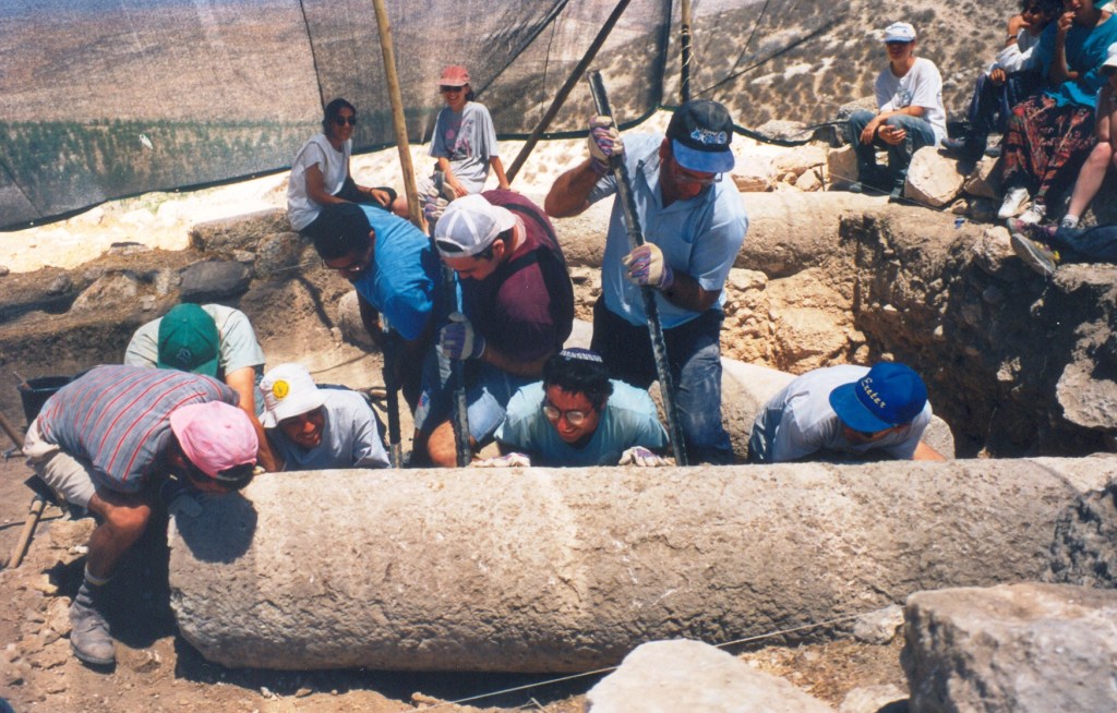
Between the years 1995-1999 five seasons of archaeological excavation were conducted at Horvath Yattir under the direction of Professor Hanan Eshel, Professor Jodi Magness and Eli Shenhav. These excavations were sponsored by the Jewish National Fund in conjunction with Bar Ilan University, during the course of which the author of this dissertation participated at first as an archaeology student in the Department of Land of Israel Studies and subsequently from 1996 as an area supervisor.
The structural remains of Horvath Yattir are spread across the eastern slope of the hill in a crescent-like form, whereas the crest of the hill and the western slope were not settled. The structures visible jutting above the surface of the land prior to excavation postdate the Byzantine period, as they incorporated stones from the earlier Byzantine buildings in secondary use. Dwellings in the northern part of the site include caves, gates, stairs and open courtyards. In one of the caves half of an extremely large and elaborately engraved doorpost was discovered bearing geometric patterns, the other half of which was found outside the cave in secondary use.
During the course of the five seasons of excavation carried out at Horvath Yattir four areas were excavated: Area A at the top of the hill, Area B on the eastern slope, Area C south of the site, and Area D at the upper part of the northern slope. Excavation of Area A produced no significant material. The excavation of Area B focused on a square structure, built entirely of stone, which at one time was identified by Zvi Ilan as a synagogue, however, the excavations established that the building was a mosque.
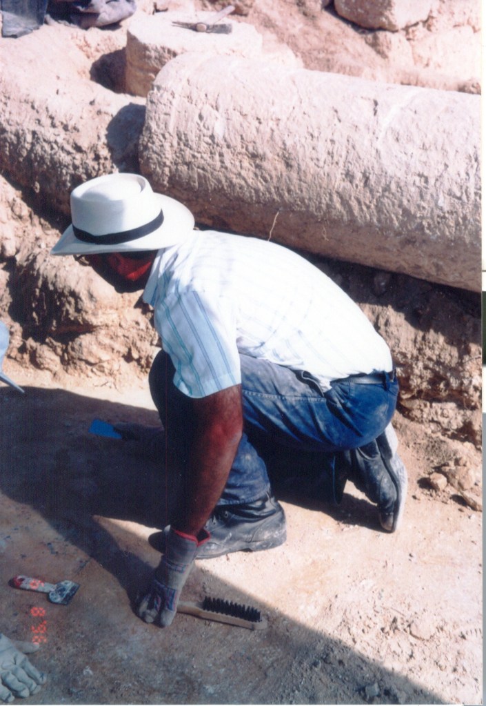
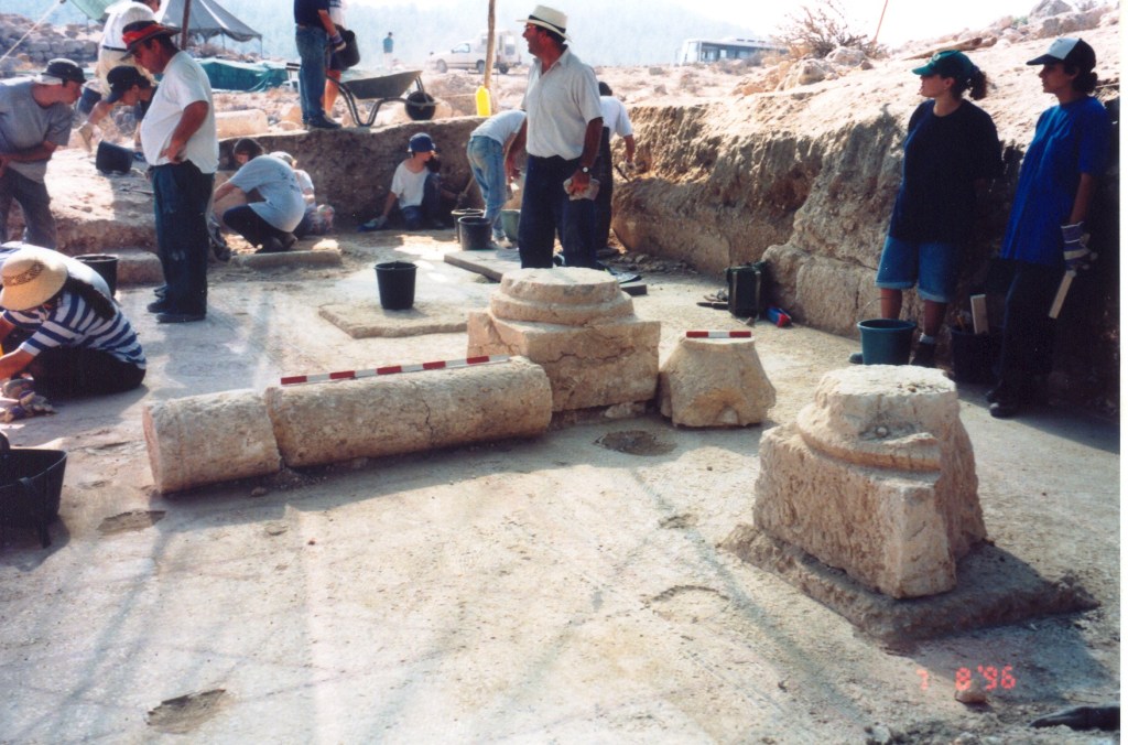
In Area C, a spur on the southern side of the site, the remains of a monastic church, 13 x 24 m., were excavated exposing a basilica structure with a mosaic floor decorated in magic symbols. In the hall, two rows of six columns once stood on pedestals that were placed on a square stone foundations, stylobat, that extended just a few centimeters above the mosaic floor. The columns were discovered in different contexts: laying on the surface, over of the mosaic, and some in secondary use incorporated in later walls of rooms built in the area of the church. Of the twelve pedestals only five were discovered, each different from the other. Three of the pedestals were placed on round bases, one pedestal has heptagonal and one is octagonal. Six capitals were found two of which are heavy conical shaped and covered in a white plaster that concealed engraved Maltese crosses, and four Nabataean capitals belonging to the first century C.E. It appears that these capitals were originally features of a large building constructed in the first century C.E.
A mosaic floor was discovered throughout the entire church, with the exception of the southern aisle. In the northwestern corner of the hall there is a niche in the floor meant for a water urn, probably used to wash the feet of those entering the church. A similar phenomenon was discovered in the mosaic floor of the nearby synagogue at Horvath Susyia. The mosaic floor in the aisles is simply decorated in a crowstep pattern, whilst the mosaic found in the apse is decorated in geometric shapes of diamonds and circles. In the nave, two phases can be discerned in the mosaic carpet. The earlier phase was more meticulously laid and was decorated in the well-known vine motif forming medallions that encase birds and animals.
The later phase is divided into 23 horizontal bands which encompass magic symbols. In the center of the mosaic there is a large cross, and beneath it a Greek inscription in twelve lines translated reads “This work was completed in the month of March in the sixth Indiction, of the year 526 of the era of the city, for the benefit of the salvation and the aid of Thomas, the most holy, abbot of the monastery. [The work was done] by my hands, Zacharis, Ben Yeshi, the builder, servant of God”. Leah Di Segni, based on the calendar of Provincia Arabia the city referred to is Elusa, originally dated this inscription to 631-632 CE.
Two years later in the atrium of the church, a second Greek mosaic inscription was discovered. This six line inscription translates: “All of the work in building the church including the mosaic was carried out in the time of Yochanan [John] Ben Zachariah, who honours God, the diakon, the head of the monastery, during the month of May in the ninth Indiction in the year 483 according to the city’s calendar.”
The discrepancy between the dates of the two inscriptions led Di Segni to a new dating of the inscriptions. One suggestion is that the first phase of the mosaic was laid in 588-589 CE and the second phase was laid 631-632 CE. However, another suggestion is that the church was constructed in 682 CE and renovated in 725 CE.
In Area D, at the top of the eastern slope, sections of a second church were discovered. Despite the poorly preserved state of this Byzantine basilica excavations exposed a larger and more elaborate structure than the Area C church. The orientation of this church is off from the east by some 45º southward. Excavation of the church floor exposed a natural cave containing the skeleton of a young woman along with a lamp dating to the first century C.E. to the Bar Kokhba Revolt. It is likely that these are the remains of a refugee who found her death here while hiding from the Romans in either the First Jewish Revolt or the Bar Kokhba Revolt. The discovery of these skeletal remains by the founders of the church are what may have lead them to constructing the building in its present location and in an unusual orientation.
As the church apses have eroded down the slope it is not possible to determine the entire length of the building, however, the length of the hall is greater than 12 m. and the width of the entrance hall is 12.5 m. whilst the aisles are 2 m. across. Massive stone stylobates cut across the entire length of the hall providing the foundations on which the pedestals for the columns were placed.
Three different types of capitals were discovered: two pilaster capitals of which no parallels have been found in Israel found in the wall of a room built in the southern part of the church subsequent to the Byzantine period; four capitals decorated on four sides with a type of conk shell motif, hitherto unparalleled as well; and the third type is a Corinthian capital discovered in the construction of the opening of a water cistern excavated in the narthex of the church.
The church was paved in an elaborate mosaic floor of which only a few sections have survived, parts of which were at one time repaired with a simple white mosaic, while other sections appear to have been intentionally damaged apparently during the early Islamic period. Of the original mosaic only part of the floor of the southern aisle was survived which was decorated in a diamond motif, a narrow band of running wave frames the central part of the nave. An eagle is depicted in the northwestern part of the carpet with his body facing north and his head south looking toward the center of the hall, the church entrance. Across from the entrance in the narthex, in the southern aisle mosaic, a Greek inscription was found of four lines, which translates: “In the days of the most holy Bishop Theodoros and Sabinios the Presbyter, all of the work on the mosaic was done [by] Absobo and Jonathan and Jeremiah in the fourteenth Indiction.” As no date reference is made and there is no way of identifying Bishop Theodoros and Sabinios the Presbyter it is not possible to date this inscription.
The earliest study of Christianity of the southern Judaean Hills is by Andres Everistos Mader between 1911-1914 in his book on the basilicas of Southern Judaea. In the introduction of his book, Mader notes the lack of correlation between the artifacts and Eusebius, who mentions only two Christian villages in the area, Yattir and Anaea. Mader counted some 30 basilica churches in the area of southern Judaean Hills, from Horvath Tawas in the north and to Ksefe (H. Malhata) in the south. His study included descriptions of structural remains, some of which are based on those of Victor Guérin and the plans of five churches from the south Hebron Hill region.
An archaeological survey of the southern Judaean Hill was carried out in 1968 as part of the Survey of Judaea, Samarian and the Golan Heights directed by Moshe Kochavi. In the publication of the survey, Kochavi notes the intensification of settlement in the Byzantine period. In the framework of the survey Kochavi identified 16 churches in the area of Mount Hebron ten of which are in the south Hebron Hill area.
A considerable amount of information on the Christian villages in the Land of Israel has been collected by Belarmino Bagatti. Baghetti, who traveled throughout the Land of Israel, published his studies on early Christian villages in Galilee, Samaria, Judaea and the Negev between the years 1971 and 1983.
David Alon excavated the site Horvath Abu Hof, adjacent to Horvath Rimon. This site, in which three churches were identified and two were excavated, has yet to be published scientifically, as is the case with the numerous sites that have undergone salvation excavations along the route of the construction of the Israeli Security Fence.
A list of all of the known sites, to date, of settlements during the Byzantine period have been compiled and mapped out, from the south Hebron Hills, the Ziph Desert and the northern Negev, including sites previously identified as Christian and since been proven otherwise at the end of Chapter 4 of this dissertation.
The character of the monastic church at Horvath Yattir together with Eusebius’ emphasis on the Christian character of the village, and the discoveries of inscriptions in the Hebron Hills and the northern Negev, as well as documentation found amongst the Genizah documents, strengthen the assumption that the south Hebron Hills area was populated with distinct Christian communities that were not associated with the greater Christian establishment.
In this paper I have isolated those details that provide some insight into the Christians of the south Hebron Hills in light of the archaeological finds at Horvath Yattir and at neighboring sites from the Byzantine period.
© May 2020
